Using Wetlands for Flood Protection
May 2015

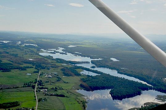
During Irene, the Otter Creek in Rutland swelled reaching a peak discharge of 15,700 cubic feet of water per second (cfs) and flood waters caused tremendous damage. Thirty miles downstream Middlebury is situated on the Otter Creek, but conditions there were quite different. The maximum peak discharge was only 6,180 cfs. Within four days the storm flow in Rutland had returned to normal, but in Middlebury flows did not even peak until then. Middlebury flows remained high for another two weeks and there was no flood damage! The dramatic differences in the Otter Creek at these two points can be explained by the presence of a vast, 9,000-acre complex of wetlands, in the floodplain of the Otter Creek between Middlebury and Rutland. The wetlands stored flood waters, slowly releasing them over time so that Middlebury and points downstream never experienced the full force of the flood. Businesses remained open and life went on as usual.
The story of the Otter Creek in Rutland and Middlebury provides a stark reminder about the importance of wetlands and floodplain access to ameliorate flooding. Throughout our region wetlands have been lost to dredging, filling and development. Their loss exacerbates flood damage during Irene-like events. While the Otter Creek Wetlands are massive, there are many smaller places where floodplains could store more water. Restoring wetlands and increasing river access to floodplains will limit downstream flood damages.
The Consider Bardwell Farm in West Pawlet, Vermont provides an example. The farm produces cheeses from goat milk collected on premises and Jersey cow milk from their neighbors. The current owners, Angela Miller and Russell Glover, began the operation in 2000, though the eponymous Consider Bardwell started Vermont’s first cheese-making co-op on the site in 1864. To promote healthy grasslands, grazing goats rotate between pastures spread over 300 acres. The Boston Globe called the farm’s Mettowee cheese “the creamiest chevre ever”, and its Manchester was included in Wine Spectator’s list of 100 great cheeses.
In 2007, farm owners used conservation grants to remove 2,000 feet of a berm that constrained the Indian River to a narrow channel between the Delaware and Hudson Rail Trail and an old corn field, now pasture. Berm removal allowed the river access to extensive flood storage to the west. Areas downstream saw little damage during Irene – clearly the added flood storage helped.
Berm removal also helped avoid flood damage along Gully Brook in Castleton. Gully Brook parallels Birdseye Road near its confluence with the Castleton River just south of Route 4A. At the point where the land around the brook levels off, the stream was bermed in 1959 to protect adjacent cropland and pasture. Berming increased the velocity of the water and its ability to carry sediment which the stream then deposited as it reached the Castleton River. Sediment accumulation led to regular flooding of the Traverse Farm barnyard and cattle pasture. The farmer found himself regularly removing sediment from the stream. Scientists from the Agency of Natural Resources suggested taking out the upstream berm to allow the river to deposit sediment where the berm was, thus reducing the risk of downstream barnyard flooding and the need to dredge the channel. The berm came out in 2004 and indeed land and property damage during Irene was minimal, as predicted. Property owner Bob Traverse told the Poultney-Mettowee Conservation District, “Gully Brook did as well as any stream in Vermont” during Irene.
Examples like these inspired other communities not to rebuild berms destroyed following Irene. In Forestdale a berm washed out. The Neshobe River flooded basements, carved two-foot deep ditches along the road, and scoured farm fields. Rather than trying to recreate the berm, 14 acres of farmland were placed in river corridor easement, increasing the opportunities for the Neshobe to store water during subsequent floods. Freeman Brook in Mt. Holly wiped out portions of a berm along Freeman Brook Road. The town has opted not to rebuild so this stream will also have access to additional floodplain storage during future storms.
The massive scale of the Otter Creek Wetlands makes the lesson about the importance of floodplain storage more dramatic. Yet, there are numerous small-scale examples of berm removal and other stream channel and wetland restoration efforts intended to restore access to floodplains that also demonstrate the importance of maintaining and enhancing floodplain storage.
Lake Look is a monthly natural history column produced by the Lake Champlain Committee (LCC). Formed in 1963, LCC is the only bi-state organization solely dedicated to protecting Lake Champlain’s health and accessibility. LCC uses science-based advocacy, education, and collaborative action to protect and restore water quality, safeguard natural habitats, foster stewardship, and ensure recreational access.
Get involved by joining LCC using our website secure form (at www.lakechamplaincommittee.org), or mail your contribution (Lake Champlain Committee, 208 Flynn Avenue - BLDG 3 - STUDIO 3-F, Burlington, VT 05401), or contact us at (802) 658-1414, or lcc@lakechamplaincommittee.org for more information.